Preface of GPNRS
July 28, 2020
Integrated Land Use & Development Master Plan (ILDP) for Gambella Peoples’ National Regional State
Phase II of IDP and SIDA’s support
HoA-REC&N initiated the development of an Integrated Landuse and Development Plan for Gambella Peoples’ National Regional State (GPNRS) in 2013 to contribute to the sustainable development of the region. The goal of developing an Integrated Landuse and Development Plan (ILDP) is to transform the lives and land-resources of the peoples of Gambella through optimal and coordinated use of the region’s resources such as land, water, forest, wildlife, fisheries, etc. The ILDP will be developed with full participation of the ILDP facilitators (sectoral government offices), drivers (communities), and competent guiding experts. During the first phase of developing the ILDP, HoA-REC&N accomplished a number of major activities with the funds obtained from the Embassy of the Kingdom of the Netherlands.
The funding was used first to establish facilitation structures (steering and technical committees at the federal and regional level) and to establish field coordination offices. Second, by involving grassroots communities, HoA-REC&N finalized the ‘first cycle studies,’ which focused on production-based and other basic studies. Third, field officers collected necessary primary spatial data and produced maps. It is recalled that in January 2015, HoA-REC received in a ceremony a 1:50, 000 scale digital topographic map f GPNRS from the Ethiopian Mapping Agency. Finally, based on the results of all the studies, HoA-REC&N’s Gambella Office is now producing production-based preliminary landuse plan.
In order to complete the ILDP (the second phase of the initiative), The Swedish International Development Cooperation Agency (SIDA), represented by the Embassy of Sweden in Ethiopia, granted 23 million Birr for the next one and half years (From December 2016 – June 2018). The agreement was signed by Dr. Admasu Tsegaye, President of Addis Ababa University, and Mrs. Annika Jayawardena, Head of Bilateral Development Cooperation, SIDA on 6 December 2016.
The Gambella project will focus on three major outcomes during this coming project period. First, it will ensure full participation of facilitators and drivers in the ILDP development process. The project envisions engaging grassroots drivers through community consultative groups with facilitators to carry out the planning, as it was done during the first phase of the initiative.
Second, HoA-REC&N will develop a holistic and Integrated Landuse and Development Master Plan. In this regard, it will conduct the second cycle of studies focusing mainly on infrastructure-based studies, land tenure and policy and Strategic Environmental and Social Assessments to ensure its compliance with the environmental and social safeguards. The first and second cycle studies will be synthesized into one ILDP for Anywa, Majang, and Nuer zones, Gambella City, Itang Special Woreda and Gambella region as a whole.
Lastly, the project will establish an ILDP enforcement system and mechanisms. This includes establishing data/information management centres and monitoring and evaluation systems.
[/cmsmasters_tab][cmsmasters_tab title=”Overview”]
Overview
In a terrain of numerous perennial rivers, vast permanent and semi-permanent wetlands, extensive woodlands, lowland and montane forests, the Gambella Peoples’ National Regional State (GPNRS), is among the landscapes with a prominent bio-cultural diversity in the Horn of Africa Region. The region shares both human and wildlife dimensions as well as the effects of conflicts with the neighbouring Boma-Jongeli landscape of the Republic of South Sudan. Within this unique ‘wilderness’ that forms the transition between Guinea – Congolian and Somali – Maasai Biomes exists the little known second largest mammal migration in Africa. This involves the seasonal migration of more than 1.1 million White-Eared Kobs traversing between South Sudan and this part of Ethiopia. The Gambella landscape is a dry season home-range of at least half of the total population and a host for about 50,000 of resident White Eared Kob. Therefore, with its unique ecosystem, numerous navigable rivers, and the ever-improving infrastructure, goods and service, Gambella could feature to be an internationally renowned prime destination for eco-tourism. The region could also potentially qualify as a new UNESCO World Heritage Site, encompassing an important Ramsar Site – Duma Wetland (additionally harbouring important populations of Nile-lechwe and Shoe-billed stork), and also including Majang Montane Forest –, which has similar biophysical characteristics with Sheka UNESCO Biosphere reserve. In a positive note, the last several years of peace has brought about renewed interest in the accelerated development of the region. The region’s extensive fertile and “seemingly idle” land, with abundant rainfall and huge irrigation and hydropower potential has attracted both domestic and foreign investors. Consequently, since 2008, around 200,000 hectares of land has been leased to more that 407 investors – more that half of this being leased to a handful foreign and local investors. Apart from expanding in the agricultural sector, the Gambella Region also has an outstanding opportunity to capitalise on its natural resource base, and to integrate different land use options such as agriculture, fisheries, game ranching, ecotourism development areas, community conservation areas, etc. Apart from ecotourism development, the region could benefit from other forms of payment for ecosystem services (e.g. REDD). Moreover a network of protected areas, safeguarding the various ecosystem’ functions, goods and services, will serve all land use options.
In spite of Gambella’ rich natural resource base and potential for sustainable development, the region has remained one of the least developed and most food-insecure in the country. Nevertheless, development, without integrated land use and development plans often fall short in considering ecological systems and natural cycles, and too often natural features are considered in isolation of the processes which they are a part-of. Without adequate consideration for ecosystem processes and the interconnectivity between life forms (biodiversity), sustainability becomes an unattainable virtue. Developments can only be sustainable if they are compatible with the natural and ecological processes that form an integral part of a landscape. The agricultural investment schemes in the region are underway without adequate environmental impact assessment. This has been of concern of numerous studies which indicated that such large-scale investments have usually involved clearing natural forests, which are important wildlife areas, unique wetlands and huge water catchments of the hydrological networks. This is disrupting the existing ecological functions, which will in turn negatively affect the sustainable productivity of the agricultural lands and rudimentary fishery business and ultimately exacerbate the impact of climatic change. On top of this, the influence on the very survival of the local communities can be an obvious source of conflict. Already, our multi-year ecosystem and biodiversity monitoring results and existing scenarios indicate that there are overlaps between wildlife home ranges vs. major investments vs. local communities. Particularly, the Duma wetlands are the major convergence points of wildlife, local community livelihoods (e.g. fishing and hunting), large-scale agricultural investment and pastoralist livestock herders (e.g. the fullata). These wetlands are the last shelters to the last population of Nile Lechwe and Shoe billed stork – endangered and vulnerable antelope and bird species worldwide, respectively.
With the above in perspective, HoA-REC&N aims to contribute to the development and implementation of a holistic and integrated land use plan for the region, which is a rational system of correcting the divergence between care and utilization of land and land resources. This integrated landuse and development plan will be a basic reference document for any development interventions so that the land and its resources do effectively contribute to the sustainable environment, social and economic growth and transformation of the region. In 2011, a consultative meeting was organized by HoA-REC&N to reflect on the need to develop holistic and integrated land use planning. The meeting involved the regional government, heads of various federal government institutions, numerous conservation and environmental organisations and the private sector. During the meeting, recognizing the potential that the Gambella landscape offers, the stakeholders appreciated the need for the planning idea. Members reached at a consensus to establish Land Use and development Planning Steering and Technical Committees whose major roles will be to provide the necessary policy and technical guidance for the initiative. The HoAREC&N developed this initiative into a proposal and submitted to the Embassy of the Kingdom of Netherlands and obtained part of the funding in 2012.
[/cmsmasters_tab][cmsmasters_tab title=”The Planning”]
The Planning
The Integrated Land use and Development master Plan (ILDP) is a plan being produced for guiding the careful, optimal and responsible development of land and water-based resources of Gambella Peoples’ National Regional State (GPNRS) as an entity entrusted to the current generation to be able to transfer it to the next at least at the quality that the current beneficiaries borrowed it; while, at the same time, the land and water-based resources do effectively contribute to the sustainable economic growth and continued social transformation of the Gambella people. The ILDP is the rational system of correcting the divergence between care and utilization of land and water-based resources based on scientific parameters, reasoning, trade-off analysis and negotiations. The plans will be prepared at regional, zonal (Anuya, Nuer and Majang), Itang special Woreda and Gambella City levels. The regional level ILDP plan will be prepared in 1:250,000 scale, the zonal levels (Nuer, Anywa, Majang and Itang Special Woreda) will be in 1:50,000 scale where as the Gambella city will be prepared in a scale of 1:5000.
The main goal of ILDP is contributing to the sustainable transformation of the lives and land-resources of GPNRS by way of guiding the optimal use of the land and water-based resources through provision of coordinated, aligned and harmonized landuse and development master plan as a guide. It targets at:
- Supporting economic transformation of the beneficiaries by allocating land according to its use potential and avoiding landuse conflicts in Gambella,
- Enabling speeded-up and improved social transformation of the beneficiaries GPNRS,
- Guarantying sustainable environment for GPNRS.
The preparation of the Plan stresses on facilitation and interaction with the genuine and active involvement of:
- Facilitators (concerned federal, regional, zone and Woreda-level government institutions), that are taking part in steering and technical committees, as well as in expert-counterpart arrangements,
- Plan driving beneficiaries (Smallholder communities as well as the large and small private-sector investors, who are organized in line of 31+ livelihood-sectors, and
- The plan-guiding experts who are recruited as private consultants chosen based on their excellence in education and experience.
In summary, ILDP is an institution-facilitated, beneficiary-driven and Expert-guided undertaking.
[/cmsmasters_tab][cmsmasters_tab title=”Key Activities”]
Key Activities
- Establishing ILDP-facilitation structures at federal and regional levels –steering and technical committees composed of different sectoral ministries, bureaus and agencies;
- At federal level, the state minister of Ministry of Agriculture and Natural Resources (MoANR) chairs the federal level steering committee. Similarly, the Director of Land Administration and Use Directorate of MoANR chairs the federal level technical committee. Genuine responsibility, participation and commitment of the federal level steering and technical committee is ascertained by each upon signing a common framework of engagement (CFE). At the federal level, the director of HoAREC&N serves as the secretariat. Deputy Ministers of 15 relevant ministries are represented in the FSC. The major role of the Federal Level Steering Committee (FSC) is giving policy guidance and approval of the plan document for an official use. At regional level, bureau heads and core-process owners of the regional bureaus, authorities and organizations are members the steering committees and technical committees respectively. The Vice-president and head of the Bureau of Agriculture and natural resources chair the regional steering committee. The director of the Land utilization, Environmental protection Authority, chairs the regional technical committee.
- Registering the households of the region and clustering them as per their major livelihood categories, and establishing Community Consultative Groups (CCGs) on the basis of economic growth area centers so that the grassroots beneficiaries drive the ILDP planning process;
- Hiring competent experts who guide the planning process and conducting the First Cycle Studies – Production-based and other basic studies such as Agriculture, Forestry, Aquatic ecology and fisheries, Wildlife habitat studies and tourism, Ecology and biodiversity, Beekeeping and honey production and marketing, Aquaculture and fish production and marketing, Range and livestock management, Hydrology and sanitation, Gender, Socioeconomic studies, Soils, soil morphology and geology, and Weather and climatology;
- Initiating Second Cycle Studies by the ILDP-guide experts – This involved engaging experts in , land tenure, policy and infrastructure-based studies – Surface mining, Value chain and agro-industry, Marketing and business, Education, Energy, Health, Extension /institution, Policy and law, Settlement planning and demography, Land and water management, Road and transport, Town /urban planning, Urban waste management, and Strategic Environment Assessment
- Reviewing and critiquing all the sectoral report by the federal and regional committees
- Consolidating the sectoral plans and respective illustration albums of maps and reconciling competing landuse claims
- Identifying livelihood-sector economic growth project ideas to help develop full-fledged development proposals;
- Getting buying-in from parliament for endorsement of the plan and establishment of enforcement support-system and mechanism
- Mainstreaming the consolidated plan with the existing and upcoming national and regional scale Growth and Transformation Plans (GTPs).
[/cmsmasters_tab][cmsmasters_tab title=”Expected Outcomes”]
Expected Outcomes
- The ILDP will become the basic guide (reference) document for any development interventions to increase productivity, are sustainable and meet the needs of the society. The final ILDP report will be developed and endorsed by the parliament with enforcement mechanisms for its implementation;
- The initiative also included identification of 31+ project ideas that need to be further developed at full-blown bankable project proposal level for implementation;
- The Integrated Land Use and Development Plan opts for a sustainable development of the Gambella Peoples’ National Regional State (GPNRS) by integrating alternative land use options for development while ensuring sustainability of value-added environment. The ILDP aims at using land for what it is best and contributing to socioeconomic transformation of the people of the region and beyond. By doing so, it triggers the creation of private sector enterprisers in environment-conscious industry, service and market expansions. It empowers beneficiaries and effectively links them to conflict-free and sustainable land use options. It aspires for making the GPNRS a growth-corridor model where the environment, modernization and commercialization are harmonized and aligned to the national GTPs for better success.
[/cmsmasters_tab][cmsmasters_tab title=”Challenge”]
Challenge
ILDP is a plan document to be produced in full scale to guide land use and development at regional level. It is also assumed to serve as a model for land use and development planning at federal and other regions’ level. In addition, this plan is not to be shelved as many other plan-documents. There shall be projects to be prepared and implemented. All these can be effectively prepared and implemented when the capacity is built at regional and federal levels. This capacity building and project development efforts are keys for using ILDP in action and transforming the lives and landscapes of the regions. This is why additional funding becomes crucial. Details on additional funding requirements are prepared looking for potential donors who share these ideals.
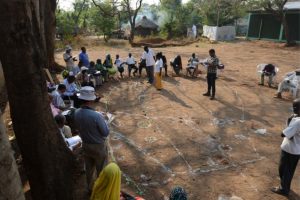
ILDP Participatory Planning Process: Grassroots communities driving the resource mapping and planning exercise while the experts are guiding them
ILDP Photo Gallery


